Location: 60 57’ 0 N and 810 46’ 15 E to 60 50’ 0 N and 810 51’ 30 E; 768290 N and 584691 E to 755407 N and 593920 E; 3km south of Pottuvil in the Ampara District, of the Eastern Province.
Area: 300 ha
Altitude: Sea level
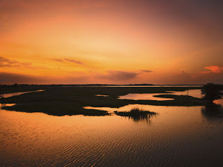
Overview: Arugam Kalpuwa is a shallow, brackish water lagoon with some fringing mangroves and extensive marshy areas to the north. It is an important habitat for large numbers of water birds, and the lagoon is also important for prawn fisheries. Surrounding areas also have extensive rice fields. The area is a popular tourist destination, and is well known among surfers for the waves off the nearby beaches. Pollution, unplanned development and sand mining are threatening the lagoon and adjacent natural ecosystems.
Physical features: The lagoon is located in Arugam Bay, and the coastline in the area contains sand dunes, headlands and broad barrier beaches. It is connected to the sea by a narrow channel and is seasonally tidal. Much of the area has been altered for human use, either for agriculture, human settlements, or tourism development. Arugam Bay is situated in the low country dry zone, where the temperature can vary from 180C on rainy nights to 380C during the day in drier months, with a mean average annual temperature of 27.40C. The area receives about 700 – 1,700 mm of rainfall per year with 60% falling during the northeast monsoons between October to February. Most of the province has a dry spell of three months with fairly dry conditions prevailing between May-September. Salinity within the lagoon varies seasonally and can be over 30 ppt at times. Winds are generally moderate, ranging from 7–15 km per hour with stronger winds during the evening.
Ecological features: The lagoon is an important habitat for large waterbirds, including migratory ducks, shorebirds, gulls and terns. The lagoon is surrounded by open forest, grassland, rice paddies and other cultivated land while some mangrove forests are also found. Additionally, there are numerous home gardens, which comprise part of the urban landscape. Natural ecosystems are mostly in a degraded to semi-degraded state. Trees such as Terminalia arjuna, Thespsia populnea, and mangroves such as Rhizophora mucronata, Bruguiera spp., Acanthus spp. and Avicennia marina are common.
Noteworthy fauna: Aquatic birds include Phalacrocorax spp., Ardea cinerea, Casmerodius albus, Anastomus oscitans and Himantopus himantopus.
Noteworthy flora: Information not available
Land use: Fishing is carried out in the lagoon, mainly as a subsistence fishery for prawns. Grazing of livestock and cultivation of rice and other crops is carried out in the adjacent areas. Some areas have been developed for tourism infrastructure such as hotels and guesthouses
Possible changes in land use: Based on the current trends in land use in the area, an increase in land used for agriculture, tourism development and livestock grazing can be expected
Hydrological and biophysical values: The lagoon is important for flood control, and is also important for nutrient cycling within the coastal ecosystems of Arugam Bay, including near-shore marine waters.
Social and cultural values: The lagoon is important for traditional subsistence fishing for local communities. There are also numerous archaeological sites in the vicinity, including the Muhudhu Maha Viharaya, a 2000-year-old Buddhist temple of particular importance.
Scientific research and monitoring: No detailed surveys have been carried out on the lagoon. IUCN has conducted some rapid assessments including an assessment of Tsunami impact on natural ecosystems of the area.
Conservation education: Information not available
Recreation and tourism: Surfing is the most popular tourist attraction in the area, and although the lagoon is not extremely important as a tourist attraction, it adds to the scenic value of the area. Even during periods of civil unrest, the Arugam Bay area maintained the most vibrant tourism economy of the east coast, largely due to surfing. Arugam Bay has also been identified for tourism development by the CTB.
Conservation measures taken: Under the USAID funded PCMA, an early warning system, sustainable fisheries and tourism, good governance, and capacity building projects are being implemented in the Arugam Bay area. The lagoon fishery is managed by the Pottuvil and Arugam Bay Fisherman Association, which regulates fishing effort and methods.
Conservation measures proposed: The Arugam Bay area has been proposed as a SAM site by the CCD.
Disturbance and threats: Pollution of the lagoon by agrochemicals draining from the adjacent rice fields and disposal of sewage and domestic waste affect water quality. Unplanned and unregulated tourism development including construction within the setback areas and encroachment into the wetland area have degraded natural habitats, along with extensive cattle grazing and land clearing for agriculture. Sand mining is carried out near the lagoon mouth and may affect its hydrology and salinity by causing the bar to remain open for a longer period. The spread of invasive alien species such as Salvinia molesta, Xanthium indicum and Pistia stratiotes are also threatening native vegetation and the hydrology of the lagoon. The lagoon was also badly affected by the December 2004 Tsunami.
Land tenure: The lagoon is state owned, while the surrounding areas are partly state-owned and partly private owned.
Management authority and jurisdication: The area is under the jurisdiction of the local DS.
References: ARCADIS Euroconsult (2003a); ARCADIS Euroconsult (2003b); IUCN (2005a); Mallawatantri (2005)

No comments:
Post a Comment